
I have spent the last two days making more images along the Chattahoochee River from I-20 up to Roswell. It has been a very hot two days as well and with some of the terrain I have been through, I hope I don’t get poison Ivy. I was able to photograph the last remaining portion of the “Outer Defensive Line” for Atlanta. It is over near Crestlawn Cemetery. It is a beautiful cemetery, it has a great view of downtown and if you go to Casey’s Hill and walk to the back part of the cemetery where the residential area starts, you can get a great view to the Northwest and you can see Kennesaw Mountain. I also shot some images of other earthworks, river crossings and structures. For the last three days I have made about 4,000 images. I am so far behind on editing it’s not funny.
Category: http://schemas.google.com/blogger/2008/kind#post
Photography Day 22 is done!
I spent the day doing a very detailed study of the Chattahoochee River Line and the Shoupades. I was able to visit 5 of the Shoupades that are left as well as a seven gun battery. After covering the River Line I moved a little to the North West and made images of the Smyrna Line and the areas around the Battle of Smyrna and the Battle of Ruff’s Mill, including the Concord Covered Bridge. Part of the original mill is still standing as well. It was a grist mill and was spared by the Federal troops. The covered bridge was built after the war to replace the one that was burned by the Federals on the July 4th, 1864. From there I went to the Lovette School and made some images of the Earthworks there and also made some images of the “trading rock” in the river at Pace’s Ferry. On the way home I stopped in Vinings and photographed the Pace house and the railroad tracks. I will be back in that same general area tomorrow to photograph some other locations. A good day, even though it was hot and humid. I had about 29 gigs of data which works out to about 1800 images. I have so much editing to do. I even had someone come up and speak to me, sort of, I was fairly deep in the woods and I was the only living soul around, but I did hear a voice right behind me and I turned to answer them and saw no one there. Creeped me out a little. I have a digital voice recorder that I attach to my tripod for taking notes, it’s faster than pulling out pen and paper, I will have to go back and listen to it see if I can here the voice on there.
150 Years Ago Today: July 5th, 1864
July 5th, 1864
In the early morning hours, General Johnston and the Army of Tennessee, retreat from the Smyrna Line and fall back to the last line of previously prepared fortifications before the Chattahoochee River. Known as the River Line, it was conceived and constructed by Brigadier General Francis Asbury Shoup, Chief of Artillery for the Army of Tennessee. The River Line had a new style of fortification in the line, they were called a Shoupade. They were diamond shaped forts built with two of the angles sticking out ahead of the line. The Shoupades were placed anywhere from 60 to 175 yards apart depending on the terrain and were connected by earthworks that intersected the Shoupade roughly in the center. The angled section in front of the line from two adjoining Shoupades, allowed for a crossfire on an advancing enemy. Each Shoupade could hold 80 soldiers shoulder to shoulder. They were also constructed to withstand an extended artillery barrage. The Confederates occupied this line until the night of July the 9th, when the retreated across the river.
150 Years Ago Today: July 4th, 1864
July 4th, 1864:
Yesterday, General Sherman entered Marietta and established his headquarters in the Kennesaw House and ordered his forces to continue the pursuit of the Confederates and attempt to engage them no matter what the cost of men and material. They must press their advantage while the Confederates are retreating.
The Federal troops continued their chase and soon, as they approached Smyrna, they began to encounter resistance from Confederate Skirmishers. They were pushed back to their main lines and the Federals began to entrench. Elements of Howard’s and Palmer’s Corps of the Army of the Cumberland advanced on the portion of the Confederate Smyrna Line near Smyrna Camp Ground, roughly the center of the Confederate line. They were engaging seasoned troops of Cleburne’s Division and suffered heavy losses. The second portion of the attack was made by Dodge’s Corps of the Army of the Ohio, they attacked the Confederate Left near Ruff’s Mill. There was a salient in the Confederate line near this point that was their target. This is where Hood’s and Hardee’s Corps met. Elements of Dodge’s Corps pushed the skirmishers of Stevenson’s Division out of their rifle pits and back to their main works, but suffered heavy losses during the assault. These attacks gained no ground for the Federals and only confirmed that the Confederate army was still in the line enforce.
They main Federal advantage gained this day, was Blair’s Corps being able to work its way around and behind the Confederate left flank. At that point they were closer to Atlanta than the main body of the Confederate Army. Blair’s movement seriously threatened Johnston and in the late night hours of July 4th and early morning hours of July 5th, Johnston fell back from the Smyrna Line to the last line of defense west of the Chattahoochee River, The River Line.
150 Years Ago Today: July 2nd, 1864
July 2nd, 1864:
Realizing that his left flank is threatened, General Johnston begins to fall back from his formidable position at Kennesaw Mountain. As General Schofield continues his movement south, he has now moved behind the Confederate left flank by about 5 miles and is about 10 miles from Kennesaw. His column also threatens the railroad supply line to Johnston, by being only 4 miles away. Schofield also controls the Sandtown Road leading to the Chattahoochee River only 6 miles east. McPherson’s Army of the Tennessee is also pushing around the Confederate left and moving toward the Chattahoochee River as well.
With this threat, Johnston has no choice but to fall back. He moves his army to a previously prepared line near the Smyrna Camp Ground. This line is only to be used to delay Sherman’s advance until the Confederate wagon train is safely across the Chattahoochee.
150 Years Ago Today: July 1st, 1864
Since the Federal assault on the Kennesaw line on June 27th, General Schofield has continued to push south toward Nickajack Creek. He has pushed past the Confederat right and is being reinforced by General McPherson’s Army of the Tennessee. Schofield is soon far to the rear of Johnstons left flank. Johnston realizes he is vulnerable and will have to retreat from the Kennesaw Line. General Johnston begins to make plans for his retreat from the line and sets a time line to have his troops begin their movement on the next night.
New Battle of Atlanta App by Emory University
Emory University has released a new smart phone app that will guide you through the Battle of Atlanta. It runs off of a website and there is nothing to down load. It will guide you via GPS to the locations and includes a brief description of the events that took place at each location. There are even parking tips. Here is the link to the site: Battle of Atlanta App
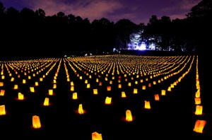
Photography Days 20 and 21 are done!
I spent this past Friday and Saturday out at Kennesaw Mountain National Battlefield Park. They were hosting a special event over the weekend to celebrate the 150th Anniversary of the Battle of Kennesaw Mountain. I started out Friday morning with a minute by minute real time walk through of the Federal assault at Cheatham’s Hill. Ranger Jim Ogden, led our group of about 100 people through the walk. He is a great speaker with a very vast knowledge of the Civil War. After the walk, I photographed some reenactors at Cheatham’s Hill and then went to the 24 Gun Battery for the Union Artillery demonstration. It was cool to see the batteries being used in the same place they were set up 150 years ago. I also photographed the Federal encampment, complete with a blacksmith, at that location. The next day I went to the Visitors Center and photographed the activities there. Made some portraits of reenactors and photographed the “Fashion Show” that displayed what civilians of different classes would have worn. I also went to the top of the mountain to photograph the Confederate Battery that was doing demonstrations. Saturday night I went to the memorial service at the Illinois Monument. A very moving ceremony with 3400 luminaries in the field to represent the soldiers the fell here in battle.
150 Years Ago Today: June 27th, 1864, The Battle of Kennesaw Mountain
June 27th, 1864
The battle of Kennesaw Mountain was really an extended operation last for several days before and after the 27th. Troops were under small arms and cannon fire daily, the 27th was day of the main Federal Assault at Cheatham’s Hill, also known as the Dead Angle, as well as the area of Pigeon Hill and the remainder of the Federal left. After days of a stalemate, General Sherman was frustrated and ordered a frontal assault on the Confederate Lines. The attack was to begin at 8:00am on the 27th, but was delayed for nearly an hour. Their goal was to break the Confederate line at what they thought was the weakest point. They chose Cheatham’s Hill due the salient in the line. General Sherman ordered General McPherson to use his Army of the Tennessee to attack the right of the Confederate line as a diversion to the main assault. McPherson’s diversionary attack was carried out against Big Kennesaw, Little Kennesaw, and Pigeon Hill. General Schofield, who was still positioned astride the Powder Springs Road near Kolb’s Farm, was ordered to keep extending the Federal right flank in an attempt to reach the end of the Confederate lines and turn their flank. General Thomas and his Army of the Cumberland were positioned in the center of the Federal lines.
The main Federal assault was carried out by elements of Palmer’s XIV Corps and Howard’s IV Corps. They were attacking the salient angle that was manned by Cheatham and Cleburne of Hardee’s Corps. The Confederates were outnumbered, but were behind a strong line of works. The Federal troops took a beating and at one point on the hill, there was a dead spot. The Southern soldiers could not fire upon this spot due to the position of their works and the angle of the hill. The Union troops in this spot began to dig in with their bayonets, tin cups and dinner plates. They were only about 25 to 30 yards from their objective. During the night, shovels and picks were brought up to facilitate easier digging and an attempt to tunnel into the hill and under the Confederate works was made. The plan was to pack it with powder and blow up the works, but the tunnel was abandoned after only making it about half way to the Confederate line.
Federal losses were just over 3,000 and the Confederate losses were about 1000. This was a tactical defeat for the Federal Army, but Schofield eventually made it to the end of the Confederate line and began moving to flank General Johnston. This forced Johnston to withdraw from his lines at Kennesaw Mountain and towards the Chattahoochee. There are many stories of Gallantry, Bravery, and Humanitarian acts during the battle. The stories and accounts from the diaries of the men who fought and died here make for excellent reading and paint an vivid picture of what happened here.
Photography day 19 is done!
Yesterday I spent the day with a local Roswell Historian named Michael Hitt. He has authored multiple publications and drawn many maps that show historic elements with modern roads together. He has mapped out all the Civil War entrenchments and earthworks in the Roswell area and many of the works all along the Chattahoochee River. Many of these sites are difficult to find on your own, so Mr. Hitt offered to give me a tour of the locations. We covered all the major spots involving the Civil War and the Chattahoochee River from the area of Island Ford Park all the way down stream to a spot near I-20. He has done some excellent work and I recommend reading some of his publications. Many of them are for sale at Bulloch Hall in Roswell. I can not really say enough about the incredible job he has done of mapping out the actions along the river in Roswell and Vinings as well as Johnston’s River Line. Please visit his site at http://www.michaelhitt.com/
